This clip summarises the main hazards facing the Philippines. An excellent summary
Tuesday, 13 October 2020

Thursday, 8 October 2020
Multiple hazard hotspots - the Philippines
Here is the first video about the Philippines - specifically Typhoon Haiyan.
Here is the second, about volcanoes and earthquakes in the Philippines.Friday, 2 October 2020
Tectonics case studies
Here are the very best videos for the case studies you are building up.
Eyjafjallajökull documentary
Montserrat volcano
Nevado Del Ruiz [warning this video contains some upsetting images]
Mount St Helens 1980
Christchurch Earthquake, New Zealand
Mt Pinatubo, Philippines 1991
Mt Nyiragongo 2002Thursday, 10 September 2020
Tectonic hazard map - using scribble maps
The first task is to create a hazard map using scribble maps. https://www.scribblemaps.com/ Register using your email address and start playing! The idea is to have this an ongoing map which we can refer to throughout the course, and build on it as we develop our understanding of case studies.
<br>
Decide what you want to put on the map: a good start might be plate boundaries
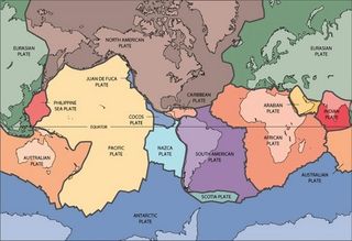 Next, watch this series of documentaries about tectonic hazards: volcanoes, tsunamis, earthquakes. Using the case studies mentioned, label your maps with the following: name, location, date, key facts (including death toll and any other significant impacts). Do additional research on these tectonic events.
Next, watch this short clip that remember the victims of the Armero tragedy. Find out more about what happened in one of the world's deadliest volcanic eruptions from this link Nevado Del Ruiz, Colombia
The Armero Tragedy at Nevado Del Ruiz is important as it provides a study into what happens when things go very wrong. Also watch this short film about Mt St Helens - this volcanic eruption happened in 1980, 5 years before the tragedy at Armero, Colombia, and yet the impacts were very different, in spite of the eruption being so much larger.
My first enquiry question for you is: which part of the world is at greatest risk from tectonic hazards, and why? Consider: population, levels of development, and the physical nature of the tectonic event. Post your thoughts in the comments below. Best of luck, Mr Robbins
<br>
Decide what you want to put on the map: a good start might be plate boundaries
After watching this, repeat the process with this documentary about earthquakes.
Next, watch this short clip that remember the victims of the Armero tragedy. Find out more about what happened in one of the world's deadliest volcanic eruptions from this link Nevado Del Ruiz, Colombia
Thursday, 11 June 2020
The globalisation of coronavirus
Hi everybody, please watch this video:
Here are all the maps I refer to. The first shows the ancient Silk Road: this was the main trading route between Europe and Asia. Until around 1450, India and China were the centres of world economic power, and goods and people mainly traveled west along the Silk Road across Central Asia. Associated with the Silk Road was the main sea route south of Persia and Arabia across the Indian Ocean

This next map shows the spread of the Bubonic Plague in its worst outbreak in the late 14th Century (which went on to kill a quarter of Europe's population). Sure enough, it followed exactly the same route as the Silk Road, as traders transmitted the disease along the way, causing outbreaks along its route. 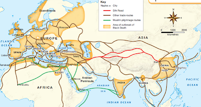
Look at this map which shows in even greater clarity the link between outbreaks and the trading routes, and how long it took for the plague to spread. Look at the key. Why did it take so long?

Now, we're going to jump forward to present day. This next map shows the facebook connections and
interactions. The places lit up the most are the world's most connected cities - global hubs. These are also the places that experienced major coronvirus outbreaks.

As with this next map, what makes these most interesting is how the coronavirus spread from its origin in Central China. The countries first affected were, by and large, CORE countries: the most developed industrialised nations. But there's more than that - it wasn't the entire country. So, for example, it was Northern Italy affected first, not the South. Northern Italy is much more developed and INTERCONNECTED with other global hubs. This means Italians living there travel more and much more widely than Italians living in the South. As a result, coronavirus spread rapidly in outbreaks in towns in the Northern region of Lombardy. They now believe that skiing trips in Northern Italy were a source of the virus that then spread to other major cities (Madrid, London, New York). The East coast of the US was then affected - particularly New York, and then the West coast and California.
The next group of countries affected at the SEMI-PERIPHERY countries - mainly the EMERGING economies of Brazil, India, South Africa. South Africa, for example, isn't expecting its peak of infections until July/August. Whereas with the medieval plagues which took 3-4 years to reach parts of Europe from its origins in Asia, with coronvirus it's spread around the world in 3-4 months.
The last group of countries to be affected and experience major outbreaks are the least developed, least globalised countries in the PERIPHERY. Although the health care systems are much less advanced than those in the global CORE, they have much more time to prepare for them, and as their populations are 'younger' than the core, there is hope that they won't be affected as badly as we might normally expect.
This map below shows travel time to major cities. The lighter the colour, the quicker it is to reach a major city. Again, the lighter the colour, the quicker coronavirus spread in that area.

So, then on to solutions: if you're in charge of controlling coronavirus, what can you do? Close all the major airports of the world? But then goods and food can't be flown in. Close the airports to just travellers, but not freight? But if you close the airports the airlines and travel industries collapse, causing the loss of millions of jobs. Yes, but you save lives by slowing down the spread and buying yourself time. Yes, but the economy crashes and jobs are lost! Herein lies the conflict between the economic and the social. Interestingly, environmental concerns have been pushed to the margins this year - even though carbon dioxide emissions have dropped a staggering 17% since lockdowns were started. This argument runs through everything geographical - trying to balance economic concerns with social concerns and there is no perfect answer.
So to sum up, understanding coronavirus is to understand globalisation and the migration of people. You can no more stop globalisation than you can stop coronavirus, despite all the 'big talk' of some world leaders. But you can slow it down and control the speed of its spread - and to do so you are constantly juggling social and economic concerns in a time of crisis.
Wednesday, 6 May 2020
Welcome to A-Level Geography!
Welcome to all our Y12 A-Level students for September 2020! Some of you may have already decided on Geography A-Level; some of you might be undecided. Please watch this video, subscribe to our youtube channel, and contact me at orobbins@sedgehillschool.co.uk.
Tuesday, 11 July 2017
Loss of biodiversity and culture
Read this, make notes on what is happening
https://www.theguardian.com/environment/2014/jun/08/why-we-are-losing-a-world-of-languages
https://www.theguardian.com/environment/2014/jun/08/why-we-are-losing-a-world-of-languages
Thursday, 6 July 2017
Resistance to cultural diffusion
This news clip demonstrates the tension created by the cultural diffusion of American Corporate Capitalism, not only with indigenous societies in developing countries, but also in developed countries such as France.
Summarise what is happening here:
Summarise what is happening here:
Wednesday, 5 July 2017
Social & environmental impacts of hyper-urbanisation
Recently we've explored the global shift in manufacturing (offshoring), and now, in services too (outsourcing).
As a result of these two processes, emerging countries have experienced astonishingly rapid economic growth. We studied the environmental impacts of these changes in China, but we need to also look at India.
The best resource for this is here, 'Slumming it' with Kevin McCloud. Create a mindmap with two main branches: social and environmental. There is of course overlap between the two. Watch both parts
As a result of these two processes, emerging countries have experienced astonishingly rapid economic growth. We studied the environmental impacts of these changes in China, but we need to also look at India.
The best resource for this is here, 'Slumming it' with Kevin McCloud. Create a mindmap with two main branches: social and environmental. There is of course overlap between the two. Watch both parts
Wednesday, 28 June 2017
Y12 - international migration - low-skilled labourers and elites
The clips from yesterday's lesson. Please make notes on what is happening and why
Thursday, 22 June 2017
Y12 - globalisation and megacity growth
Please use this link to complete the handout on megacity growth
BBC - megacities interactive
Then highlight the different statements into whether they are for (a) developed or (b) emerging/developing megacities
BBC - megacities interactive
Then highlight the different statements into whether they are for (a) developed or (b) emerging/developing megacities
Friday, 16 June 2017
Y12 - impacts of globalisation on ecology and biodiversity
For Tuesday:
Research and make notes on these three links. They focus on different impacts of China's rapid rise.
Infrastructure
https://www.theguardian.com/cities/2016/may/10/china-pearl-river-delta-then-and-now-photographs
Housing and social problems
https://www.theguardian.com/cities/2017/mar/20/changsha-changing-mao-growth-housing-services
Pollution and chemical leaks
https://www.theguardian.com/cities/2017/may/23/city-exploded-china-growth-tianjin-disaster-inevitable
For each of the links, please explore the interactive/time-lapse maps and also watch the drone footage for the last link
Research and make notes on these three links. They focus on different impacts of China's rapid rise.
Infrastructure
https://www.theguardian.com/cities/2016/may/10/china-pearl-river-delta-then-and-now-photographs
Housing and social problems
https://www.theguardian.com/cities/2017/mar/20/changsha-changing-mao-growth-housing-services
Pollution and chemical leaks
https://www.theguardian.com/cities/2017/may/23/city-exploded-china-growth-tianjin-disaster-inevitable
For each of the links, please explore the interactive/time-lapse maps and also watch the drone footage for the last link
Thursday, 8 June 2017
Y13 - FOR TOMORROW
Learn this model - AT LEAST THE SUBHEADINGS and 1 or 2 of the topics. Reference it - (Blaikie et al, 1994)
https://en.wikipedia.org/wiki/File:PAR_model.pdf
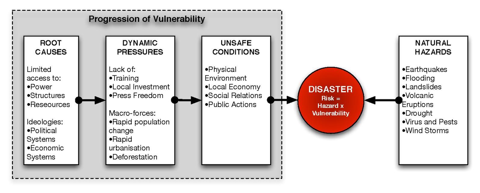
Then, learn all the main facts for our case studies.
Tohuku 2011, Japan,
Nevado Del Ruiz 1985, Colombia
Eyaffajokul 2010, Iceland
Pinatubo, 1991, Philippines
Haiti, 2010
Mt St Helens, 1980, USA
Italy 2015/16
Indian Ocean Tsunami, 2004
Memorise the names of sources - at least 5.
Memorise the names of websites & organisations - eg. "Corruption Perception Index, Transparency International - NGO".
Learn the VEIs of Pinatubo, Nevado Del Ruiz, and Eyafajjallokul
https://en.wikipedia.org/wiki/Volcanic_Explosivity_Index#/media/File:VEIfigure_en.svg
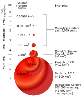
https://en.wikipedia.org/wiki/File:PAR_model.pdf
Then, learn all the main facts for our case studies.
- Plate tectonic cause
- year
- magnitude (Richter & VEI)
- social cost (no. dead)
- economic cost
- environmental cost (eg. 2 million trees [Mt St Helens])
Tohuku 2011, Japan,
Nevado Del Ruiz 1985, Colombia
Eyaffajokul 2010, Iceland
Pinatubo, 1991, Philippines
Haiti, 2010
Mt St Helens, 1980, USA
Italy 2015/16
Indian Ocean Tsunami, 2004
Memorise the names of sources - at least 5.
Memorise the names of websites & organisations - eg. "Corruption Perception Index, Transparency International - NGO".
Learn the VEIs of Pinatubo, Nevado Del Ruiz, and Eyafajjallokul
https://en.wikipedia.org/wiki/Volcanic_Explosivity_Index#/media/File:VEIfigure_en.svg
Sunday, 28 May 2017
Y12 - Globalisation - half term work
The half term work comes in two parts:
1. To complete the work we began on 'switched off' and 'switched on' places around the world, answer this question. Write a detailed paragraph (half a side) with 2 examples for each of the four factors.
"Analyse the physical, political, economic, and environmental reasons why some locations are 'switched off' from globalisation".
To reach the higher levels, remember to pick holes in your own points. So, just after having mentioned Nepal and how it's landlocked, you then do a big "however" and mention Switzerland, and try to explain why, in this case, being landlocked is not a problem.
Use the KOF map of globalisation to find some examples.
2. Download the PDF file from this link Global Shift PDF
a) define the global shift
b) identify the causes/what has enabled it to happen
c) mindmap the impacts on China and India
1. To complete the work we began on 'switched off' and 'switched on' places around the world, answer this question. Write a detailed paragraph (half a side) with 2 examples for each of the four factors.
"Analyse the physical, political, economic, and environmental reasons why some locations are 'switched off' from globalisation".
To reach the higher levels, remember to pick holes in your own points. So, just after having mentioned Nepal and how it's landlocked, you then do a big "however" and mention Switzerland, and try to explain why, in this case, being landlocked is not a problem.
Use the KOF map of globalisation to find some examples.
2. Download the PDF file from this link Global Shift PDF
a) define the global shift
b) identify the causes/what has enabled it to happen
c) mindmap the impacts on China and India
Monday, 22 May 2017
Y12 - measuring globalisation
Read p.162-163. Mindmap the ways the KOF index and the A T Kearney Index measure globalisation.
Which is a better measure? Explain your decision.
Next, use this KOF map to mindmap/create a table showing the physical, environmental, political, economic factors that explain 'switched on' and 'switched off' places around the world. Use examples!
Eg: (under 'physical') Nepal - mountainous - lack of internet infrastructure; landlocked - no ports for access to trade routes.

Which is a better measure? Explain your decision.
Next, use this KOF map to mindmap/create a table showing the physical, environmental, political, economic factors that explain 'switched on' and 'switched off' places around the world. Use examples!
Eg: (under 'physical') Nepal - mountainous - lack of internet infrastructure; landlocked - no ports for access to trade routes.

Wednesday, 5 April 2017
Y13 - Thursday 6th April
For today's lesson we aim to complete a Unit 2 mock (the paper I gave you yesterday). The aim is to complete this paper in the double lesson - remember that the real exam gives you just 1 hr 15 min.
We need to aim for speed and accuracy in our writing, hence why we are using the essay plans we created overnight.
When you have finished these, please leave them on my desk.
Best of luck
Friday, 31 March 2017
Unit 4 - factors that affect the EFFECTIVENESS OF managing hazards
Unit 4 - factors that affect the EFFECTIVENESS OF managing hazards
Read this link and make notes on it
https://www.e-education.psu.edu/geog030/node/379
Here are some case studies to consider:
PLACE
Remoteness/accessibility: Nevado del Ruiz, Colombia, 1985, 2007 Solomon Islands earthquake
Hotspots: Mt Merapi, Indonesia
Eruption types: Hawaiian, Strombolian, Vulcanian, Peléan, Plinian, Surtseyan, Submarine, Subglacial, Phreatic eruptions (for these, a specific eruption case study might not be necessary), super-volcano (caldera) - Campi Flegrei
Earthquake types: blind-thrust, mega-thrust, interplate & intraplate, deep-focus quakes shallow quakes - Haiti 2011; deep - Chile 2010, aftershocks (Nepal 2015)
PEOPLE
Population density & distribution: 1964 Alaskan earthquake vs 2010 Haiti earthquake, Kamchatka Peninsula, Campi Flegrei, Naples,
Coasts compared with landlocked places: Indian Ocean tsunami 2004, Nepal 2015
Demographics: Japan 2011 (ageing populations) https://www.theatlantic.com/international/archive/2011/03/japans-earthquake-and-the-hazards-of-an-aging-population/72892/
Culture & beliefs: Indian Ocean Tsunami 2004 (Andaman islands) http://news.bbc.co.uk/1/hi/world/south_asia/4181855.stm
Disadvantaged groups: Banda Aceh (2004) https://en.wikipedia.org/wiki/Free_Aceh_Movement
Education: Indian Ocean Tsunami (2004) https://www.youtube.com/watch?v=V0s2i7Cc7wA
Employment: farmers in the Phillippines, fishermen in the Indian Ocean Tsunami, tourists (2004 Tsunami
POWER - TO FOLLOW
Read this link and make notes on it
https://www.e-education.psu.edu/geog030/node/379
Here are some case studies to consider:
PLACE
Remoteness/accessibility: Nevado del Ruiz, Colombia, 1985, 2007 Solomon Islands earthquake
Hotspots: Mt Merapi, Indonesia
Eruption types: Hawaiian, Strombolian, Vulcanian, Peléan, Plinian, Surtseyan, Submarine, Subglacial, Phreatic eruptions (for these, a specific eruption case study might not be necessary), super-volcano (caldera) - Campi Flegrei
Earthquake types: blind-thrust, mega-thrust, interplate & intraplate, deep-focus quakes shallow quakes - Haiti 2011; deep - Chile 2010, aftershocks (Nepal 2015)
PEOPLE
Population density & distribution: 1964 Alaskan earthquake vs 2010 Haiti earthquake, Kamchatka Peninsula, Campi Flegrei, Naples,
Coasts compared with landlocked places: Indian Ocean tsunami 2004, Nepal 2015
Demographics: Japan 2011 (ageing populations) https://www.theatlantic.com/international/archive/2011/03/japans-earthquake-and-the-hazards-of-an-aging-population/72892/
Culture & beliefs: Indian Ocean Tsunami 2004 (Andaman islands) http://news.bbc.co.uk/1/hi/world/south_asia/4181855.stm
Disadvantaged groups: Banda Aceh (2004) https://en.wikipedia.org/wiki/Free_Aceh_Movement
Education: Indian Ocean Tsunami (2004) https://www.youtube.com/watch?v=V0s2i7Cc7wA
Employment: farmers in the Phillippines, fishermen in the Indian Ocean Tsunami, tourists (2004 Tsunami
POWER - TO FOLLOW
Capitalism: Indian Ocean Tsunami 2004 http://www.naomiklein.org/shock-doctrine/resources/part7/chapter19/thailand-tsunami-survivors-group
Democracy vs dictatorship: Chile vs Iran http://www.slate.com/articles/news_and_politics/fighting_words/2010/03/long_live_democratic_seismology.html
Transparency vs corruption: Haiti 2010, Chile 2010 https://www.foreignaffairs.com/articles/2010-07-15/disaster-politics
The role of NGOs: http://nacla.org/news/ngos-and-business-poverty-haiti
Local communities: Nepal 2016 http://blogs.lse.ac.uk/southasia/2016/05/03/community-participation-should-be-at-the-heart-of-nepals-post-earthquake-reconstruction-process/
https://www.hands.org/localvolunteers/
https://www.hands.org/localvolunteers/
Government agencies: FEMA (federal emergency management agency) http://disasterphilanthropy.org/issue-insight/fema/
Political instability (links to Banda Aceh 2004): http://www.dw.com/en/how-political-instability-affected-nepals-disaster-preparedness/a-18411259
Thursday, 30 March 2017
Y13 - Unit 3 work, Thursday 30th March
Hi all, apologies that I'm not here today.
Peer assess the 10 and 15 markers, using the criteria below.
 As a group, decide on another section A question (both 10 & 15 markers) from a paper. Repeat the process from yesterday, using the cheat sheet if necessary.
 As a group, decide on another section A question (both 10 & 15 markers) from a paper. Repeat the process from yesterday, using the cheat sheet if necessary.
Friday, 24 March 2017


Subscribe to:
Posts (Atom)